The Satellite Communications (SATCOM) sector is witnessing a remarkable surge in growth, fueled by groundbreaking advancements in technology and the emergence of private space companies.

This dynamic landscape is creating a wealth of opportunities, continually redefining and revitalizing this forward-thinking field. For those drawn to the allure of space exploration, the complexities of satellite communication, and the thrill of revolutionary technology, a career in the SATCOM industry might be a perfect fit.
Education serves as the springboard for a successful career in this rapidly evolving industry. Maintaining a competitive edge in SATCOM requires a keen eye on current trends, an ear to the ground for emerging talent, and an ability to adapt. For employers, identifying which universities are churning out the brightest minds in SATCOM offers a strategic advantage during recruitment processes. For students and those at the onset of their career, selecting the right university is a critical first step towards carving a successful career path in SATCOM.
EVONA recognizes the crucial role that education plays in crafting the future of SATCOM. With the industry’s rapid expansion, the need for highly educated, forward-thinking individuals in SATCOM is at an all-time high.
By analyzing employment data from leading SATCOM companies, we’ve identified a select group of universities that consistently produce the industry’s top talent. Interestingly, 90% of graduates landing jobs in the SATCOM sector graduate from American universities, with the University of Maryland leading the charge.
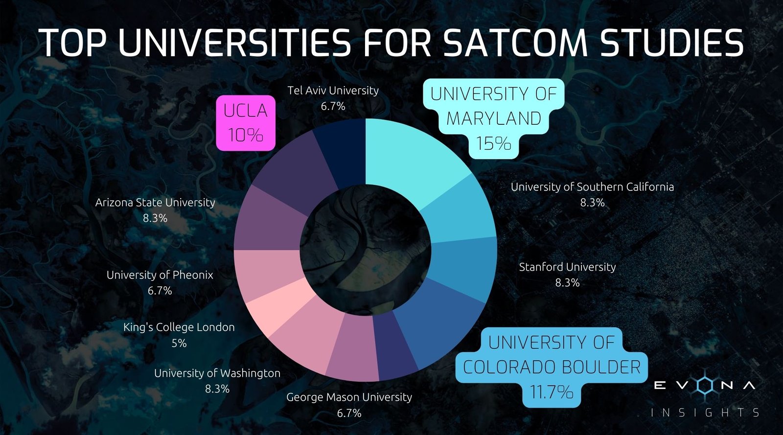
Top 10 Universities for SATCOM Studies by Industry Hires
 University of Maryland, US
 - University of Colorado Boulder, US
- University of California (UCLA), US
- Stanford University, US
- University of Southern California, US
- University of Washington, US
- Arizona State University, US
- George Mason University, US
- University of Phoenix, US
- Tel Aviv University, Israel
When it comes to the world of SATCOM, the US stands as a dynamic hub of innovation, forging ahead with remarkable advancements in space exploration and technology.
The US: A Global Hub for SATCOM Education

The US has earned a global reputation as a leading hub for SATCOM education, a reputation that has been forged through its vigorous space programs, innovative research environments, and an influential network of world-leading institutions.
The Universities Space Research Association (USRA) lies at the heart of this educational framework. As a vital link, USRA connects universities, government bodies, and a wide spectrum of other organizations. By offering an expansive array of resources, driving research opportunities, and delivering expert technical insights, USRA fuels a collaborative atmosphere that nurtures innovation and growth. Its steadfast commitment to high-quality standards elevates the industry relevance of its member universities’ research, establishing a gold standard within the sector.
Also central to the US’s prominence in SATCOM education is the relationship between NASA and leading American universities. This partnership, enabled by regular funding for space exploration initiatives, creates a robust foundation for the sector’s development. NASA’s commitment to fostering academic programs focused on space-related studies accelerates progress in the SATCOM industry, effectively preparing students to navigate the constantly evolving opportunities and challenges within the field.
Tel Aviv: A Global Hub for SATCOM Education
While the United States dominates the SATCOM landscape, there are notable universities outside the US that excel in providing world-leading education in satellite communications. Situated in Israel, Tel Aviv University has distinguished itself as an international center for SATCOM education, drawing in students and researchers from across the globe.
With strong industry ties, research collaborations, and cutting-edge facilities, Tel Aviv attracts students and researchers worldwide. Its strategic location in Israel’s thriving tech ecosystem offers abundant opportunities for internships, collaborations, and networking with satellite communication companies and start-ups. The Department of Electrical Engineering, led by esteemed faculty, also provides rigorous programs covering wireless communications, signal processing, and satellite systems. Tel Aviv University fosters innovation and entrepreneurship, encouraging students to pursue groundbreaking ideas and contribute to SATCOM industry growth.
The Top Three Universities for SATCOM Studies
University of Maryland
 Location: Baltimore, Maryland
- Gender Split: 51% male, 49% female
- Total Enrollment: Approx 41,200 students
- USRA Membership: Yes
- Funding: NASA allocated $32.5 million to extend its partnership with the University of Maryland, enabling continued management of data on small celestial objects—a field significantly advanced by UMD’s research
- World Ranking for Space Science: 24th
- Notable Collaborations: Partnerships with NASA’s Goddard Space Flight Center and the Joint Space-Science Institute (JSI)
- Key Departments: Department of Astronomy, Department of Aerospace Engineering, and Maryland Robotics Center
- Relevant Courses: Offerings include spacecraft systems and design, wireless communications, signal processing, space robotics, and spacecraft autonomy
- Geographic Benefits: Proximity to Washington, D.C. offers numerous internship and employment opportunities with government agencies and private companies. Close ties with NASA’s Goddard Space Flight Center provide unique opportunities for research and learning.
University of Colorado, Boulder
 Location: Boulder, Colorado
- Gender Split: 55% male, 45% female
- Total Enrollment: Approx 37,000 students
- USRA Membership: Yes
- Funding: Top university recipient of NASA research awards
- Notable Collaborations: Partnerships with NASA, National Oceanic and Atmospheric Administration (NOAA), and National Institute of Standards and Technology (NIST)
- Key Departments: Ann and H.J. Smead Department of Aerospace Engineering Sciences, Laboratory for Atmospheric and Space Physics, BioServe Space Technologies Center, Department of Electrical, Computer, and Energy Engineering
- Relevant Courses: Course offerings include space and satellite systems, wireless communications, signal processing, and control systems
- Geographic Benefits: In the heart of the American aerospace industry, students benefit from a rich network of space research organizations and companies. Boulder also offers an excellent quality of life, fostering a positive learning environment.
University of California, Los Angeles (UCLA)
 Location: Los Angeles, California
- Gender Split: 40% male, 60% female
- Total Enrollment: Approx 44,000 students
- USRA Membership: Yes
- Funding: Ranked as a top public university for securing federal funding, including for space-related research and SATCOMs
- Notable Collaborations: Collaborative partnerships with NASA, NOAA, and Jet Propulsion Laboratory (JPL)
- Space Missions: UCLA has participated in over 50 space missions
- Key Departments: Department of Physics and Astronomy, Department of Electrical and Computer Engineering, Institute of Geophysics and Planetary Physics, UCLA’s Galactic Center Group
- Relevant Courses: UCLA offers courses in astrophysics, space physics, signal processing, network communications, and wireless technologies.
- Geographic Benefits: Located in the global hub of technology and entertainment, students enjoy access to a diverse range of industries. Proximity to companies in the Silicon Valley and renowned institutions like JPL offer excellent internship and job opportunities.
The influential role these leading universities play in shaping the SATCOM industry’s future is undeniable. They provide the knowledge, exposure, and hands-on experience necessary for the next generation of professionals to lead and innovate in this rapidly evolving field. For those aspiring to build a career in SATCOM, these institutions stand as a beacon, offering a combination of world-class education, research opportunities, and strong industry ties.
As the SATCOM landscape continues to expand and redefine itself, the question for prospective students and professionals is: how will you leverage these opportunities to forge your unique path in the industry?
Whether you’re an employer in search of top-notch talent, a student figuring out your academic trajectory, or a professional considering the next steps in your career, we’re here to give you guidance and advice. Your SATCOM journey starts with a conversation, so let’s talk.

 Listed as 21.8% of SATCOM companies’ top field of study, electrical and electronics engineering is the bedrock of SATCOM. Electrical engineers are the trailblazers who design, develop and manage the components essential to the operation of satellites. This includes power systems, telemetry devices, and other components, all of which are built to perform consistently in the harsh, unforgiving realities of space. Alongside them, electronics engineers masterfully craft miniature circuits and devices, optimising satellite weight and size while amplifying functionality. Together, this discipline forms a vanguard that consistently pushes technological boundaries in SATCOM.
 Computer science, at 14.1%, is an indispensable cornerstone in the SATCOM industry. It’s computer scientists who design and optimise the intricate algorithms and data structures that satellites rely on for their operation. They work tirelessly to ensure secure and efficient communication between space and earth, maintaining the integrity and accessibility of the massive amounts of data satellites handle. With their expertise, satellites become more than hunks of metal in orbit—they become sophisticated instruments capable of advancing humanity’s reach and understanding.
 With a substantial 9.8%, computational science – not to be confused with computer science – plays a pivotal role in the SATCOM industry. Computational science is an interdisciplinary field that uses computer science techniques, mathematical models, and simulations to solve complex problems in various scientific disciplines. It involves the practical application of computer science and mathematics to real-world problem solving. This discipline leverages the power of computational tools to simulate and solve complex physical problems associated with satellite communications. By creating models of intricate situations and systems, computational scientists offer invaluable insights into satellite design, performance optimisation, and risk mitigation. They are the analytical powerhouses who help us navigate the complexities of creating and managing advanced satellite systems.
 Mechanical engineering, standing firm at 9.8%, brings pragmatism to the innovative world of SATCOM. These engineers concentrate on the physical systems within a satellite, focusing on aspects like thermal control and mechanical structures that maintain the satellite’s physical integrity. Their work ensures that satellites can withstand the harsh conditions of space for extended periods, thereby enhancing the longevity and reliability of our space-based communication networks.
 Carrying a significant 9.5% of the weight, Aerospace, Aeronautical, and Astronautical Engineering builds the backbone of the SATCOM industry. These talented engineers design, construct, and test the spacecraft that eventually transform into our communication satellites. They are the bridge between theoretical designs and tangible, functioning satellites, their work allowing us to reach beyond the confines of our planet and into the celestial unknown.
 Holding 7.3% of the field, specialists in computer systems networking and telecommunications ensure that our planet remains interconnected. They design and implement the networks that facilitate seamless communication between satellites and earth stations. Their efforts transform a collection of individual devices into an integrated global web, keeping the world linked, no matter how remote the location.
 At 7.3%, specialists in electronics are indispensable to the SATCOM sector. These experts are responsible for the intricate electronic components that keep satellites functional. Through their meticulous work, they ensure that every signal, every byte of data, is transmitted and received correctly, enabling a symphony of seamless communication that spans the globe.
 Industrial engineers, also at 7.3%, bring a unique and practical perspective to the SATCOM industry. Their role is to enhance operational efficiency and cost-effectiveness within the sector. They ensure processes are streamlined, resources optimised, and that the production and operation of satellites remain economically viable. Their ingenuity in creating sustainable and efficient systems is a crucial contributor to the long-term growth and environmental responsibility of the industry.
 Finally, accounting for 7% of specialities, telecommunications engineering is vital to the efficient operation of SATCOM systems. These engineers manage the precious spectrum resources, promoting their efficient and effective usage. Their mastery prevents a chaotic scramble for bandwidth and ensures orderly, reliable communication channels.
 Kick-starting your career in the exciting realm of SATCOM is an exhilarating prospect, and having EVONA as your partner can give you a significant advantage. As a leading specialist in space industry staffing, we have an intimate understanding of the industry and a deep network of connections with innovative organisations driving SATCOM evolution.
 Satellites have fundamentally changed the way we observe and analyze Earth’s ecosystems and climate patterns. High-resolution images and precise data from Earth observation satellites enable real-time monitoring of climate change indicators, including deforestation, ice-sheet melting, and ocean temperature fluctuations.
 Space-based solar power, an ambitious concept in the space industry, could potentially transform our energy landscape. By capturing sunlight in space through expansive solar panels and transmitting it to Earth’s power grids, we can access an inexhaustible, clean energy source. Operating in space, solar panels receive sunlight continuously and avoid atmospheric disturbances, increasing efficiency.
 Space technologies extend beyond monitoring and mitigation, bolstering climate adaptation initiatives as well. Utilizing satellite data, early warning systems for extreme weather events—such as hurricanes, floods, and droughts—can be developed, empowering governments and communities to prepare for and respond to these threats.
 The application of space technology to ocean conservation efforts presents exciting possibilities for preserving Earth’s vital marine ecosystems. Satellite-based remote sensing provides crucial data on sea surface temperatures, ocean currents, and phytoplankton distribution, informing climate models and marine research. These insights help scientists understand the effects of climate change on ocean life and ecosystems, such as coral reefs, and the subsequent impacts on global carbon cycles. As we uncover the secrets beneath the waves, we can harness these innovations to better understand and protect our blue planet.
 Geoengineering is an emerging field that explores the potential of large-scale interventions to mitigate climate change. Space technologies could play a vital role in these endeavors. For instance, Solar Radiation Management (SRM) techniques, such as deploying sunshades in space or launching reflective aerosols into the stratosphere, could reflect sunlight away from Earth, effectively cooling the planet. Another potential approach is Carbon Dioxide Removal (CDR), which aims to capture and store atmospheric carbon dioxide, counteracting the greenhouse effect.
 Earth observation satellites equipped with advanced sensors are used to monitor various environmental conditions and natural disasters. These satellites provide critical data that enables faster and more accurate predictions, which are crucial for proactive disaster management. Continuous monitoring of environmental variables, such as weather patterns, helps meteorologists track extreme weather events, ensuring better preparedness for areas prone to natural disasters.
 High-resolution satellite imagery helps emergency managers assess damage, identify priority areas for response, and monitor recovery processes. Satellite imagery is also essential in creating accurate maps of disaster zones, invaluable for emergency responders navigating unfamiliar terrain. By overlaying these maps with data such as population density, infrastructure, and transportation networks, vulnerable communities can receive timely assistance.
 Satellite-based internet solutions, such as Low Earth Orbit (LEO) satellite constellations, offer fast and reliable internet access to remote areas. In the aftermath of a disaster, these systems can help restore connectivity, facilitating communication between affected communities and emergency response teams. This technology also promotes access to critical information, enabling residents to receive updates, alerts, and safety guidelines in real-time.
 The space industry has encouraged the research and development of new technologies specifically tailored to disaster relief efforts. This research includes the development of advanced remote sensing technologies, machine learning algorithms for data analysis, and drones for search and rescue operations. These innovations not only enhance the effectiveness of disaster response but also reduce the time it takes to reach affected populations.