What Is… Synthetic Aperture Radar (SAR)?

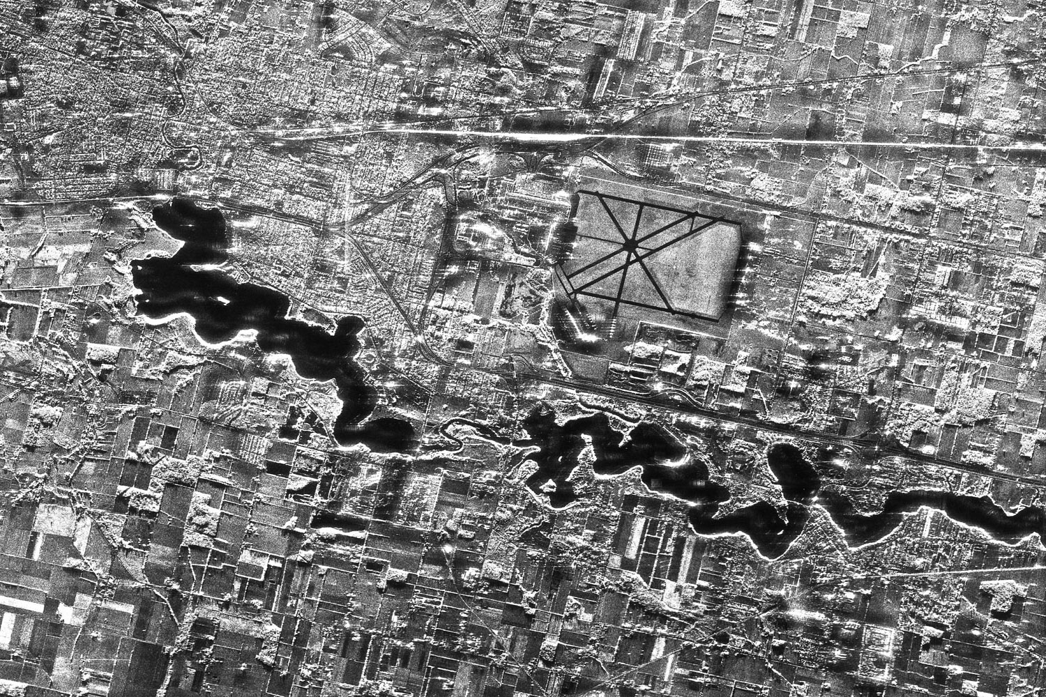
What is Synthetic Aperture Radar?

Synthetic Aperture Radar (SAR) is an incredibly powerful distant Earth observation tool used to create high-resolution images the Earth’s surface. Using a radar, SAR satellites scan and map the Earth’s surface, producing two-dimensional images or three-dimensional reconstructions of landscapes.

Synthetic Aperture Radar (SAR) is an incredibly powerful distant Earth observation tool. Using a radar, SAR satellites scan and map the Earth’s surface, producing high-quality two-dimensional images or three-dimensional reconstructions of landscapes.

Space Radar Image of Kilauea Volcano, Hawaii - PICRYL - Public Domain Media Search Engine Public Domain Search
Credit: NASA via Picryl.com


How Does Synthetic Aperture Radar Work?

SAR is an active sensor, emitting pulses of microwave radiation down to Earth that are reflected back, or ‘backscattered’, off far-away objects. The instrument then measures the distance between its sensor and the target that reflected the pulse.

SAR can determine an object’s exact location, a target’s velocity as well as the distance between objects. It can also differentiate between moving and stationary objects.

Mounted on a satellite, the radar’s beam creates a ‘footprint’ on the ground as it scans – imagine this like a spotlight. Once the microwave pulses hit the ground, they’re reflected off different objects and scattered back in multiple directions. Some of these pulses will bounce back in the direction of the satellite to be recorded. You can compare this process to a bat using echolocation.

The radar now needs to differentiate these returned pulses to understand the specific objects or landscapes that reflected them. Distance is determined by measuring the time taken for the pulse to reach the ground and return back to the radar, using the equation ‘distance = time X velocity’. In this instance, velocity is the speed of light as we know the pulses travel at this speed.

Now, we need to get more specific to calculate the direction each pulse came from. As the radar’s beam scans the ground, it notes the pitch at which the echoes are reflected. As the footprint moves, the reflected echoes’ pitches directly relate to objects’ positions within the beam. An increasing pitch means that the ground is approaching the satellite, with a decreasing pitch showing the ground receding from it. Since we’ve already calculated their distance, each specific echo can now be located from a particular intersection of the radar’s footprint.

Finally, we need to calculate the size of the object reflecting the waves. Smaller objects will reflect a smaller echo, producing a dark pixel. Medium-sized objects will reflect a medium echo, producing a somewhat brighter pixel, with larger objects reflecting back an even brighter one. Water completely reflects the pulse, creating a black pixel.

All of these elements combined and working in harmony produce a radar image of the Earth’s surface.


What Are the Benefits of Synthetic Aperture Radar?

File:Radar image acquired on 2 May.jpg - Wikimedia Commons

SAR has day, night and all-weather capabilities. It doesn’t require sunlight to function and is not affected by atmospheric conditions. It can also “see” through things like vegetation, snow, sand and smoke.

Able to collect data at different wavelengths, SAR can obtain many types of information such as water and moisture content, surface makeup, the impact of natural or man-made disasters and changes in habitat. The ability to repeatedly scan the same area regardless of weather conditions makes SAR a great tool for measuring changes in Earth’s landscapes and environment. These capabilities provide enormous value for industries such as geospatial intelligence that rely on environmental data and imaging to document and assess human activity on Earth.


What is Synthetic Aperture Radar Used For?

SAR technology provides immeasurable valuable across a long list of industries, as well as to the rest of mankind. It puts us one step ahead of the many adversaries facing our planet, allowing us to monitor, assess and remedy natural and man-made threats.

SAR has a wealth of environmental applications, such as monitoring climate change, natural disasters, ecosystem loss, pollution, forests, agriculture and offshore vessels.

  • Agriculture – monitoring surface makeup, identifying crops, monitoring growth, creating yield prediction models
  • Floods – creating flood prediction models, estimating flood depth, assessing flood damage
  • Forests – detecting and monitoring deforestation, estimating biomass and forest height
  • Subsidence – monitoring land subsidence, warning of potential infrastructure collapse or instability
  • Snow and ice monitoring – detecting and monitoring ice depletion, identifying glacier motion, monitoring water levels
  • Wildfires – penetrating smoke to monitor and assess severity and loss of forest fires
  • Offshore vessels – detecting and monitoring oil spills as well as vessel movement

SAR is also a key component of defence and security. Modern camouflage, concealment and decoy strategies are used to disguise and disrupt the appearance of military targets. As these stealth tactics develop, the nature of the threat to defence is advancing alongside technology. The clear images obtained by SAR satellites in practically any atmospheric condition allow us to develop counter-stealth solutions, maintaining a strategic edge over the opposition.


What’s the Difference Between Traditional Satellites and SAR Satellites?

Traditional optical satellites use light reflected from the sun, collecting the reflected energy off the Earth’s surface much like a camera or a human eye. When collecting images, these satellites see the world in the same way we do, clouds, weather and all.

SAR satellites, on the other hand, are active sensors that produce their own energy source. This gives them higher capabilities in a range of conditions and allows them to capture such high-quality images. As an active monitoring tool, SAR can also cover greater areas than optical satellites in much less time.

File:15ftSARimage.JPG - Wikimedia CommonsRadar allows us to see through clouds, rain, trees and in the dark thanks to the long wavelength of radio waves, in comparison to the shorter light waves used by traditional satellites. These radio waves are emitted through an antenna, or aperture, with the radar image’s resolution depending on the size of the antenna to the size of the wavelength. This means that for radio waves, a larger antenna is needed to create the same high-resolution images. This creates challenges if you want to launch your radar on a satellite to image large distant areas at a time. That’s where SAR satellites come in.

SAR satellites produce high-resolution images of large areas by moving a small aperture over long distances. This allows us to combe several viewpoints into one radar image, thus creating a large synthetic aperture.

When scanning, the Antarctic for example, a SAR satellite would be able to pick up extremely detailed surface textures, allowing us to deduce the ice’s thickness. Optical satellites would not be able to detect this level of detail and would portray a simpler image of the surface snow and ice.


Working with Synthetic Aperture Radar (SAR)

  • SAR systems engineer: responsible for the design, development, and testing of SAR systems
  • Satellite controls engineer: responsible for the design and operation of the control systems used to point and steer satellites equipped with SAR systems
  • Electrical engineer: responsible for the design and development of electronic components used in SAR systems, such as antennas, receivers, and processors
  • Data scientist: responsible for analyzing and interpreting data collected by SAR systems to generate insights and inform decision making
  • System architect: responsible for the overall design and architecture of SAR systems, including defining system requirements, specifying system components, and ensuring compatibility among components
  • Remote sensing specialist: responsible for the interpretation and analysis of data collected by SAR systems to support various applications, such as mapping, environmental monitoring, and disaster response.


SAR Salary Guidelines

  • SAR systems engineer – $138,022
  • Satellite controls engineer – $97,500
  • Electrical engineer – 104,439
  • Data scientist – $121,165
  • System architect – $154,798
  • Remote sensing specialist – $135,000


SAR Geographic Hotspots

  • Washington DC-Baltimore
  • San Francisco Bay
  • Los Angeles
  • Boston
  • New York

Whichever path you take, a career in SAR is as rewarding as it is exciting. It provides individuals with the opportunity to work on cutting-edge technology, while making a real difference in the world. With the ever-growing demand for SAR technology, the space sector is ripe with incredible opportunities for those interested in this field.


Check out our space jobs page to take the first step in your SAR career journey.

What Is… a Nano Satellite?

What is a Nano Satellite?

Nano satellites, also known as CubeSats or NanoSats, are small satellites that typically weigh less than 10 kilograms, measuring from 10 centimetres to 10 x 10 x 11.35 centimetres in size. They are an inexpensive way to send a satellite into orbit and have become increasingly popular in the aerospace industry. Nano satellites provide a range of applications including communications, Earth observation, remote sensing, and scientific research.

Nano satellites are transforming the space industry, providing new opportunities for exploration, data collection, and communication. With their low cost, small size, and incredible capabilities, nano satellites are opening up the final frontier to anyone with a dream.


The Benefits of Nano Satellites

Nano satellites have revolutionised space exploration by making it more accessible, affordable, and flexible. They offer a number of advantages that make them a powerful tool for scientific research and exploration.

Nano satellites are far more affordable to launch into orbit compared to traditional satellites. They cost significantly less in both the development and launch stages and can be launched in large numbers at the same time. This makes them ideal for carrying out scientific research, communications, or observation missions in space.

Due to their small size, nano satellites can stay in orbit for much longer than traditional satellites, making them an ideal choice for long-term observation and monitoring missions. As they are also easy to manoeuvre and reposition, they can be used to deploy payloads quickly in emergency situations.

Nano satellites also offer an unprecedented level of flexibility when it comes to mission design. With their compact design and low weight, they can be equipped with an array of sensors and instruments to collect data that was previously not possible. This provides the opportunity for new discoveries and insights about our universe.


Nano Satellites vs Regular Satellites

Nanosatellites differ offer several advantages over traditional large satellites, also known as macro-satellites. One of the most notable differences is size. Microsatellites are significantly smaller and weigh less than traditional large satellites, which can weigh several tons. On top of making them easier and cheaper to launch, this smaller size also allows for faster development, with microsatellites able to be developed and launched in a fraction of the time it takes to develop traditional satellites.

Another key difference is cost. Traditional satellites are expensive to develop and launch, with costs often running into the hundreds of millions of dollars. Microsatellites, on the other hand, are significantly less expensive to develop and launch, making them more accessible to a wider range of organisations and businesses. This cost-effectiveness also allows for the deployment of multiple microsatellites in a constellation, providing a more robust and reliable service for the customers.

In terms of technology, microsatellites can also be equipped with the latest and most advanced technologies available, whereas traditional satellites may become obsolete by the time they are launched. Due to their smaller size, they can be more easily upgraded and modified to keep up with the latest advancements.


How Long Does it Take to Build a Nano Satellite?

The shorter development time of nano satellites is a defining feature that sets them apart from traditional large satellites. While traditional satellites can take years to design, build, and launch, nano satellites can be developed and deployed in a much shorter period. This has several implications for businesses and organisations looking to launch satellites.

File:CubeSat in hand.jpg - Wikimedia Commons
Image Credit: Svobodat via Wikimedia Commons

With nano satellites, the reduced development window allows for the incorporation of cutting-edge technologies, giving organisations a competitive edge in their respective fields. Traditional satellites often become obsolete by the time they are launched, as technology can significantly advance during the design and build period.

Another advantage is the flexibility to adjust to changing market conditions. The traditional satellite development process is so lengthy that by the time it reaches orbit, the market it was intended to serve may have shifted. Nano satellites, on the other hand, can be developed and deployed in a matter of months, making them more responsive to new or emerging market needs.


A Career With Nano Satellites

The field of nanosatellites is interdisciplinary, and there are many career paths available for individuals with a range of backgrounds and skills. Whether you’re interested in engineering, operations, or business, there is a role for you in this exciting and growing field.

  • Engineering: professionals in this field are involved in the design and creation of nanosatellites, utilizing expertise in aerospace, electrical, or mechanical engineering.
  • Manufacturing: these experts play a crucial role in constructing and testing nanosatellites, ensuring they meet rigorous standards before launch.
  • Operations: this area of the field involves controlling and monitoring nanosatellites once they are in orbit, and includes data analysis, system upkeep, and problem resolution.
  • Program management: program managers oversee the development and launch of nanosatellites, making sure projects are completed on schedule, within budget, and to the required quality standards.
  • Business development: business developers identify new markets and customers for nanosatellite technology, and establish relationships with key stakeholders.
  • Research and development: this field involves advancing the current state of nanosatellite technology, discovering new applications and capabilities, and finding ways to make these systems more efficient and dependable.
  • Sales and marketing: sales and marketing specialists promote nanosatellite technology to potential clients, provide technical support, and negotiate sales.


Nano Satellite Salary Guidelines


Nano Satellite Geographic Hotspots

  • New York
  • London
  • Los Angeles
  • San Francisco Bay
  • Washington DC-Baltimore


A career in the nanosat industry offers a chance to make an impact and drive the advancement of space technology. The industry is growing rapidly, with increased demand and investment, presenting a range of opportunities for those passionate about space and technology. From technical roles such as engineering, to business and management positions, entrepreneurship and innovation, the nanosat sector has a place for individuals with a variety of skills and interests. So, take the first step towards a fulfilling and exciting career in space by exploring the many job opportunities available in the nanosat industry.


If you like the sound of a career in Nanosats, there’s never been a better time to join this exciting sector. Check out our space jobs page to take the first step in your space career journey.

What Is… Space Debris?

What is Space Debris?

Often referred to as ‘space junk’, space debris is any man-made object in Earth’s orbit that no longer serves a purpose. It includes items like disused spacecraft, inactive satellites, fragments from explosions and collisions, launch canisters, and mission-related objects.

As of April 2022, the European Space Agency reported over 30,000 pieces of space debris larger than 10cm. Some notable ones have included:

  • A Tesla Roadster (launched in 2018 by Elon Musk to the tune of David Bowie’s Space Oddity. Track its journey here)
  • A $100,000 bag of tools (dropped by astronaut Heidemarie Stefanyshyn-Piper on a spacewalk)
  • A glove
  • A tank of ammonia
  • A spatula
  • A camera


What is Causing Space Debris?

Space debris is caused by a combination of factors including anti-satellite weapons, collisions, rocket stages, explosions in orbit caused by leftover fuel and batteries, and human activity.

In addition, not enough satellites are being removed from highly crowded low-Earth orbits at the end of their mission lifecycles. Active satellites have to actively dodge fragments of objects launched into space years ago.

The United Nations requests for satellites to be removed from orbit within 25 years of the end of their lives. For some, this means pulling them into a ‘graveyard orbit’ where it won’t pose a threat to active satellites.


How Much Space Junk is There?

Amongst the 2,000 active satellites orbiting Earth, there are 3,000 dead ones. On top of this, there are around 900,000 pieces of debris ranging from the size of a marble to a tennis ball, around 34,000 pieces above 10cm, and 128 million pieces below 1cm. The total mass of debris in Earth’s orbit is estimated to exceed 9,000 metric tons.

While a few millimetres of space junk may seem insignificant, even the smallest piece can cause serious damage. When the 1983 Challenger Space Shuttle collided with a 0.2mm speck of paint at 20,000mph, it dug a significant chunk out of its window. Even this miniscule piece of space debris could have compromised a multi-billion-dollar mission.


Why is Space Debris a Problem?

Space junk poses a threat to human spaceflight and robotic missions. The debris also threatens our weather forecasting, GPS and telecommunications systems.

Collisions with debris have already caused significant damage to the International Space Station, as well as other vital satellites. With more launch activity taking place than ever before – over 4850 reported in January 2022 – the probability of collisions is rising.

In 2007, the probability of any satellite in low Earth orbit colliding with a piece of debris over 1cm was 17-20% in a year. Later that year, this increased to 25-33% when China completed an anti-satellite mission, deliberately destroying their 750kg Fengyun-1C weather satellite and creating over 3,000 pieces of debris. By 2010, the likelihood rose to 50% when two full-sizes satellites, Iridium 33 and Cosmos 2252, collided at 42,000kmph. The crash annihilated both satellites, sending over 1000 fragments over 10cm, and many more too small to track, flying into space.

In addition to causing issues in outer space, debris can pose a physical threat to us back on Earth. China made headlines recently when a 25-ton chunk of debris from their Long March 5B rocket began hurtling back down to Earth. Space junk from the uncontrolled return was later found in Indonesia and Malaysia. Even more recently, chunks of debris from SpaceX’s Dragon capsule were found scattered across Australian farmland.


Can We Clear Space Junk?

Space junk can stay in Earth’s orbit for thousands of years, if not longer. With the problem at hand getting worse, experts have been deliberating on ways to clean up space.

In March 2021, private orbital debris removal company Astroscale launched its End-of-Life Services by Astroscale-demonstration (ELSA-d) satellite. It consists of two spacecraft – a 175kg chaser and a 17kg target. Using magnets, ELSA-d will capture orbiting junk and pull it out of orbit to burn up in the atmosphere. This innovative craft was awarded the 2021 Satellite Technology of the Year Award. In its test phase, both spacecraft were sent into space to later separate and engage in a cosmic game of cat and mouse. Once in orbit, the target is ejected for the chaser to locate using its sensors. Once tracked, the chaser meets the target and launches onto it using a magnetic docking place. After securing, the target is released for further capture tests.

Astroscale reported ELSA-d’s success in August 2021, giving new hope that the spacecraft will be able to complete this same process to capture pieces of debris.

Many other posed solutions are still in their research phases. The US Defence Advanced Research Project Agency has been investigating a ‘space garbage truck’ equipped with 200 giant nets to catch orbiting debris. The collected junk would either be dragged into lower orbit or brought back to land in the ocean.

Another developing idea is the Gossamer Orbit Lowering Device, or GOLD system. This would employ a balloon thinner than a plastic sandwich bag, using gas to inflate it to the size of a football pitch. The balloon would then attach itself to large pieces of debris and eventually drag them into the atmosphere to burn up. If successful, this system could speed objects’ re-entry from hundreds of years to only a few months.

Whichever of these innovative methods gets the go-ahead, one thing is clear – and it’s definitely not space. With the sheer mass of junk orbiting Earth, we need to come up with an effective solution, and fast.

The space sector has come a long way, but our venture beyond the stars has only just begun. The sector will transform our lives in ways we never thought possible, but for the industry to thrive, humanity needs to clean up its act.


Working With Space Debris

The field of space debris offers a variety of career paths for individuals with a passion for space and an interest in preserving it for future generations. From scientists and engineers who develop new technologies to track and mitigate space debris, to policy makers and managers who create regulations and oversee programs, there is a role for every skill set.

  • Space debris engineer: developing and implementing strategies and technologies to minimize the creation of space debris and manage the existing debris population.
  • Space debris analyst: analyzing data and monitoring the distribution of space debris in Earth’s orbit to predict collisions and assess risks to active satellites and spacecraft.
  • Space Situational Awareness (SSA) specialist: maintaining a comprehensive picture of objects in space, including space debris, to support the protection of space assets.
  • Spacecraft operations engineer: overseeing operational aspects of spacecraft, including flight paths, and ensuring protection from space debris.
  • Aerospace engineer: designing, testing, and evaluating performance of spacecraft and associated systems, and developing debris removal or avoidance technologies.
  • Space policy analyst: researching and analyzing space policies, laws, and regulations related to space debris and advising on addressing the issue.
  • Space lawyer: providing legal advice and support on issues related to space debris, including liability, compensation, and international agreements and treaties.


Space Debris Salary Guidelines

  • Space debris engineer – $81,000
  • Space Situational Awareness (SSA) specialist – $137,500
  • Spacecraft operations engineer – $112,422
  • Aerospace engineer – $97,102
  • Policy analyst – $74,678
  • Space lawyer – $114,834


Geographic Hotspots for a Career with Space Debris

  • Washington DC-Baltimore
  • Los Angeles
  • Denver
  • Boston
  • Paris

Whether you’re a space enthusiast, a technical expert, or a business professional, there is a career path in space debris management that can align with your interests and skills. With the continued growth of space exploration and commercialization, the demand for professionals in this field is only expected to increase, making it an exciting and rewarding industry to pursue.


Check out our space jobs page to discover the incredible careers like this the space sector.

What Is… Python?

What is Python?

Python is a high-level, interpreted, and general-purpose programming language, first introduced in 1991. It was developed by Guido van Rossum with a focus on readability and simplicity. This has resulted in a language that is widely used by beginners and experienced programmers alike, who appreciate its clear and concise syntax. Python has evolved over the years to become one of the most widely used programming languages in the world, and its vast library of modules and its powerful functionality have been instrumental in this success.

The language’s syntax is straightforward, making it easier for users to quickly and easily create code, regardless of their level of technical expertise. This has led to the widespread use of Python for a wide range of tasks, including web development, scientific computing, data analysis, artificial intelligence, and more. In the space industry, Python is particularly useful for analyzing satellite data, planning missions, and developing simulations. This is due to its ability to handle complex tasks and its ease of use, which allows users to quickly and efficiently process vast amounts of data.


What is Python Used For?

Python is widely used for a range of tasks, including:

  • Data analysis: when it comes to data analysis and data science, Python is a highly sought-after language, offering users a range of powerful libraries for data processing and manipulation, such as NumPy and Pandas.
  • Web development: Python’s frameworks, such as Django and Flask, are widely used for web development, providing developers with the necessary tools to create and deploy high-performance web applications.
  • Machine learning: the use of Python in machine learning and artificial intelligence is well established, with its libraries, including TensorFlow and PyTorch, streamlining the process of building and training ML models.
  • Finance: with its comprehensive suite of tools for data analysis, algorithmic trading, and risk management, it’s no wonder Python has become an indispensable tool in the finance industry.
  • Science and research: in the scientific and research community, Python continues to be a popular choice, equipped with libraries for scientific computing, such as NumPy and SciPy, and data visualization, including Matplotlib, which provide researchers with the tools they need to analyze data and communicate results effectively.

Python’s versatility is one of its greatest strengths, and this is especially true in the space industry. Python can be used for a wide range of tasks, from data analysis to mission planning, and everything in between. In the space industry, Python is used to analyze satellite data, plan missions, and develop simulations. The language’s functionality and ease of use make it ideal for these tasks, allowing users to quickly and efficiently process vast amounts of data.


Python vs JavaScript

While both Python and JavaScript are popular programming languages, they are used for different purposes. JavaScript is primarily used for front-end web development, while Python is used for a wide range of tasks, including back-end web development, scientific computing, and data analysis. One of the key differences between the two languages is their syntax, with Python known for its clear and concise code. This makes it easier for those with less technical backgrounds to learn and use, making it a great choice for both beginners and experienced programmers.

Another key difference between the two languages is the type of applications they are best suited for. JavaScript is primarily used for web development, while Python is used for a wide range of applications, including data analysis and scientific computing. In the space industry, Python is the go-to choice for professionals who are looking to analyze satellite dataand develop simulations, while JavaScript is not commonly used. Additionally, Python has a larger and more robust library of modules and functions, which makes it a more powerful and versatile language overall.


A Career in Python

Python is a fantastic career option that offers numerous exciting prospects for proficient professionals who aspire to succeed in the space sector and beyond. As Python is increasingly being used across multiple industries, it has become an indispensable skill that can give you a competitive edge in today’s job market. So if you’re looking for a lucrative career that can offer stability and growth, Python is a great choice. To get ahead of the curve in this competitive industry, check out our Python Space Skills Focus.

Some of the most popular career paths for Python professionals include:
  • Software development: this is the most traditional career path for Python programmers. As a software developer, you would be responsible for designing, developing, and maintaining software applications.
  • Data science: Python is a popular language for data science and is widely used for tasks such as data analysis, machine learning, and data visualization. Data scientists use Python to process and analyze large amounts of data, build predictive models, and create data-driven insights.
  • Web development: Python can also be used for web development, either by itself or in combination with other technologies such as Django or Flask. Web developers use Python to build and maintain dynamic websites and web applications.
  • Artificial Intelligence (AI): Python is widely used in the field of AI and machine learning. AI professionals use Python to develop and implement algorithms that allow machines to learn from data and make predictions.
  • DevOps: Python is often used for automation and system administration tasks in the DevOps space. DevOps engineers use Python to automate the deployment, testing, and monitoring of software applications.
  • Networking: Python is also used for networking and system administration tasks. Network engineers and system administrators use Python to automate and manage networks, servers, and other IT infrastructure.

These are just a few of the many career paths that involve Python. The versatility of the language means that there are many other potential career paths for Python professionals, depending on your interests and skills.


Python Career Salary Guidelines

  • Entry-level Python developer – $73,551
  • Mid-level Python developer – $117,157
  • Senior Python developer – $186,61


Geographic Hotspots for Python

  • Bengaluru
  • San Francisco Bay
  • New York
  • Delhi
  • Hyderabad

With its ease of use and large library of modules, Python provides a wide range of opportunities for those who are proficient in the language. Whether you’re a beginner or an experienced programmer, learning Python is a smart career move that can open up a world of possibilities. Start learning Python today and join the growing number of experts who are shaping the future of the space industry.


Check out our space careers page to start your Python career journey today.

What Is… Geospatial Data?

What is Geospatial Data?

Geospatial data is a type of data used to identify the geographic location of an object or feature on the Earth’s surface. It is often used in mapping, navigation, and location-based services, as well as in geographic information systems (GIS) for a variety of applications. It is the basis of many decisions we make in our daily lives, from the route we take to work to the store we shop at.

This type of data is used to identify, measure, and analyse the physical features of the Earth’s surface. From mapping the location of natural resources to providing the infrastructure for navigation, geospatial data plays a vital role in many industries. By understanding what geospatial data is and how it can be used, we can better understand our world and make better decisions in our day-to-day lives.


How is Geospatial Data Used?

When it comes to mapping and navigation, geospatial data is a game-changer. The data is used to create detailed maps of different regions, allowing for easy navigation, precise planning, and insightful analysis. Additionally, GPS systems utilise geospatial data to pinpoint a user’s location, track their movements, and even plan routes. From personal navigation to commercial transportation and logistics, the applications of geospatial data in mapping and navigation are endless.

Geospatial data also plays a crucial role in monitoring and tracking changes in the Earth’s climate, such as temperature, precipitation, and sea level rise. By utilising geospatial data, scientists and policymakers can predict future changes in the climate and understand the potential impacts of these changes. This information is vital for making informed decisions about how to mitigate and adapt to climate change.

Agriculture is another industry that heavily relies on geospatial data. This data is used to map and monitor crops, soil, and weather patterns. By utilising this information, farmers can improve crop yields, manage pests and diseases, and optimis irrigation systems. Furthermore, geospatial data is used to analyse and predict crop yields, which is vital for farmers and food suppliers to make informed decisions about planting, harvesting, and storing crops.

Geospatial data plays a critical role in natural disaster response an essential tool for emergency responders to predict and plan for the impact of natural disasters. This data is used to map and track natural disasters such as hurricanes, earthquakes, and floods, providing valuable information on the potential impact of these events. Emergency responders can use this information to plan for evacuation and recovery efforts, ensuring that they are as prepared as possible to respond to the disaster. By analysing data on weather patterns, geological activity, and other factors, scientists can even predict the likelihood of natural disasters, enabling them to provide early warning systems, save lives and reduce the damage caused by these events.


What Are the Different Careers Available in Geospatial Intelligence?

Geospatial intelligence allows experts to analyse and make decisions on complex environmental, political, and economic issues. Professionals in this field must be able to interpret data from multiple sources and have a strong knowledge of mapping tools and GIS software. As such, there are many different career paths available for those interested in working in geospatial intelligence.

One of the most popular career paths within the field is that of a geospatial analyst. Geospatial analysts use their understanding of the technology to study satellite imagery, aerial photographs, and other data sources to create visual representations of terrain and identify potential areas of interest. They also use geospatial data to map population distributions, track the spread of disease, and provide intelligence to governmental agencies and private businesses.

Other careers available in geospatial intelligence include cartographers, surveyors, remote sensing technicians, and GIS technicians. Cartographers create detailed maps of geographic areas while surveyors measure boundaries, elevations, and other features of land surfaces. Remote sensing technicians operate remote sensors such as satellites to gather data from various sources, while GIS technicians develop maps and spatial databases for analysis.

In addition to these more traditional careers, the field of geospatial intelligence has seen the emergence of new roles such as geospatial intelligence officers, who combine the skills of a geospatial analyst with those of an intelligence officer to provide decision makers with strategic advice. Finally, geospatial scientists are responsible for developing new methods for collecting and analysing geospatial data.


A Career With Geospatial Data

  • Geospatial intelligence analyst: collect and analyze geospatial data to support intelligence activities and provide decision-makers with timely and relevant information.
  • Remote sensing scientist: develop and implement methods for collecting and analyzing remote sensing data to extract information about the earth’s surface.
  • GIS specialist: design, develop, and maintain geographic information systems (GIS) that help organizations visualize, analyze, and understand data in a spatial context.
  • Cartographer: create and design maps, charts, and other geospatial products that accurately represent the Earth’s surface and its features.
  • Surveying and mapping technician: conduct surveys and gather data to create maps, charts, and other geospatial products that support engineering and construction projects.
  • Location intelligence analyst: analyze and interpret location data to support business decisions and strategic planning.
  • Geospatial data scientist: develop and apply statistical and machine learning techniques to geospatial data to extract insights and support decision-making processes.
  • Geospatial software developer: design, develop, and maintain software applications that support geospatial analysis and visualization.


Geospatial Data Salary Guidelines

  • Geospatial intelligence analyst – $62,823
  • Remote sensing scientist – $79,901
  • GIS specialist – $65,463
  • Cartographer – $77,887
  • Surveying and mapping technician – $52,154
  • Location intelligence analyst – $89,586
  • Geospatial data scientist – $106,601
  • Software developer – $101,573


Geographic Hotspots for Geospatial Data Career

The US is a major player in the geospatial industry. Discover which US universities geospatial organizations are actively hiring from here.

  • Washington DC-Baltimore
  • New York
  • San Francisco Bay
  • London
  • Los Angeles

The beauty of a career in geospatial data is that there is always room for growth and development. The field is constantly evolving as new technologies are developed, and new applications for geospatial data are discovered. This provides ample opportunity for professionals to stay up to date with the latest advancements and continually enhance their skills.

A career in geospatial data offers not only a rewarding and fulfilling professional path but also a dynamic and ever-changing environment. With the increasing demand for geospatial data, now is a great time to consider a career in this field.


Check out our space jobs page to discover the amazing opportunities available to you in this exciting sector.


What Is… Asteroid Mining?

What is Asteroid Mining?

Asteroid mining is a proposed method of extracting raw materials from asteroids and other minor planets. Although hypothetical, asteroid mining poses a potential solution to Earth’s growing carbon pollution and resource depletion problems.


What Are the Benefits of Asteroid Mining?

The mining industry is responsible for pollution on a huge scale. It contaminates our air, water, and soil, destroying entire landscapes through the use of toxic chemicals such as chlorine, sulphuric acid and cyanide. In addition to producing harmful by-products, these processes are quickly adding to Earth’s resource depletion issue.

Even as we strive to become more sustainable through tools like solar panels and wind turbines, we’re creating additional needs for mining. These tools contain platinum, which requires harmful methods of extraction.

Whether we like it or not, rare and precious materials are a staple of modern life. They’re a key part of modern technology, medicine and aerospace. Currently, we seem to be stuck in a cycle of high demand, only satisfiable through harmful mining. However, we could potentially outsource these valuable elements from space.

While Earth has finite resources, there are over a million asteroids – that we currently know about – containing precious materials like platinum, gold, iron, magnesium and palladium. If we found a way to safely extract these materials, we could potentially satisfy humanity’s appetite for millions of years to come.

In the asteroid belt between Mars and Jupiter – where the majority of known asteroids orbit – some asteroids measure over 60 miles in diameter. NASA has estimated this belt to contain $700 quintillion of materials – that’s $100 billion for each person on Earth.

This amount of raw material could provide us with close to unlimited resources. However, while asteroid mining may seem simple in principle, there are some roadblocks that humans are yet to overcome.


What Are the Problems With Asteroid Mining?

One issue is cost – travelling into deep space is expensive. While there is little doubt about its benefits for sustainability, asteroid mining is not profitable enough yet. Regardless of how much an asteroid’s materials are worth on Earth, the price of getting to it and returning the resources could eclipse this figure. Considering the high initial investment cost, as well as the time it would take for a return on this, investors can be reluctant to get involved. To be truly profitable, space mining operations would need to be scaled up massively.

Another problem is deciding the best method of reliably identifying suitable asteroids, then securing them and safely extracting the materials.

In addition, sudden access to this number of materials would crash their markets back on Earth. Metal-rich asteroids could supply us with so many commodities that their prices would drop drastically.


How Would Asteroid Mining Work?

Firstly, we would have to identify resource-rich asteroids. This can be difficult to do from afar, so powerful telescopes may be the most effective way to do so.

Once identified, processing could be done by propelling the raw ore into near-Earth orbit for easy mining access. However, this would require a lot of fuel, so an alternative method could be mining them in space to return only the processed materials.

If we were to mine for materials on-site, robot prospectors could be used to automatically identify and mine specific targeted areas. Once identified, we could use heat to evaporate the desired elements with the help of giant mirrors, separating them from unwanted waste products to return to Earth.

Alternatively, ‘strip mining’ could be used. This would involve scraping away the asteroid’s surface, tunnelling into veins of materials and scraping off valuable substances. These resources would then float off the asteroid and be collected by a large canopy.


A Career in Asteroid Mining

  • Astronautical and space engineering: the design, creation, and testing of spacecraft and their components, aimed at asteroid mining missions.
  • Planetary science and exploration: examining celestial bodies, including asteroids, to comprehend their formation, makeup, and potential resources.
  • Robotics and automation: development of robotic systems and autonomous robots for use in asteroid mining.
  • Mining and extraction: the removal of minerals and resources, such as precious metals, water, and volatile compounds, from asteroids.
  • Business and finance: management of financial and business aspects of asteroid mining operations, including investment and revenue generation.
  • Marketing and communications: promoting and creating awareness about asteroid mining operations and the advantages of space resource utilization.
  • Policy and law: formulating and implementing policies, regulations, and laws regarding space resource exploration and exploitation, specifically asteroid mining.


Asteroid Mining Geographic Hotspots

  • US
  • Luxembourg
  • Japan
  • UAE
  • Russia
  • China

Asteroid mining could pave a path to a greener planet for all of us. Once the stuff of science fiction, this fascinating and innovative theory might just be the answer to some of Earth’s biggest problems. If this excites you, now is time to join this exciting and rapidly developing field.


Check out our space jobs page to take the first step in your space career journey.

What Is… a Satellite?

What is a Satellite?

A satellite is a device that is launched into space to orbit the Earth or other celestial bodies. From providing communication and navigation services to helping us observe the Earth, satellites have become an integral part of our lives. They are used to collect and transmit data and images, among many other types of information. Satellites are used for a variety of purposes, including communication, navigation, surveillance, monitoring of natural disasters, and weather forecasting.

Satellites have a wide range of applications in the modern world. They can be used for communication, navigation, surveillance, weather monitoring, scientific research, and much more. In addition to providing essential data about our planet and its environment, satellites have opened up new opportunities for space careers and jobs.

Satellites are essential for many of the services we rely on today. With advances in technology, satellites have become increasingly useful to humanity. From navigation systems to internet connections to environmental monitoring, satellites are helping us to connect and solve major world issues.


Why Do We Use Satellites?

Satellites are used to receive and transmit a wide range of data and information. Because they operate in space, satellites have the advantage of communicating and collecting data from virtually anywhere – without being hindered by terrestrial coverage limitations. They can “see” large sections of the Earth’s surface, collect data more quickly than instruments on the ground and provide services with an unmatched level of ubiquity. Here are just a few examples of the types of services provided by satellites:

  • GPS and navigation
  • Satellite telehealth
  • Emergency response and disaster relief
  • Satellite TV and radio broadcast
  • Mobile communications
  • Broadband connection
  • Remote sensing and imaging

Satellites play an important role in the exploration and utilisation of space. They are used to observe our planet, explore other planets and objects in space, monitor climate and weather patterns, communicate with spacecraft, and provide navigation assistance, to name a few.

Satellites help scientists and researchers gain better insights into what is happening in our atmosphere and beyond. They can measure temperatures, detect changes in the land, map out new routes and track the movement of stars and galaxies. Additionally, satellites are used to facilitate communication between space-faring nations and to track military assets.

Space professionals have built an array of different types of satellites for different purposes, such as communications satellites for global voice, data and video transmissions, Earth observation satellites for measuring the environment, navigation satellites for providing global positioning services, and science satellites for collecting scientific data.

The demand for space technology continues to increase and new jobs are being created for people who are passionate about space exploration. There are many career opportunities available in space related fields such as satellite engineering, satellite mission planning and operations, space research and analysis, space policy development, space law and many more. Whether you’re interested in building a satellite, using satellites to track activity in space or investigating the effects of space on Earth, there is a lot to learn about what satellites can do. Exploring the endless possibilities of satellites is an exciting way to make a career in the space industry.


Do Satellites Have Environmental Benefits?

Satellites play a critical role in monitoring and studying the Earth’s environment, and their benefits are numerous. With their advanced capabilities, satellites can provide us with valuable information on weather and climate conditions, as well as help us understand the impact of human activities on the planet.

One of the key benefits of satellites is their ability to measure and track environmental changes, such as pollution levels, deforestation, and changes in land use. This information helps researchers to gain a comprehensive understanding of the Earth’s environment and the ways in which it is evolving. Satellites are vital components in the study of climate change. Using sophisticated sensors, satellites can measure temperature, pressure, wind speed, and other meteorological phenomena, giving scientists valuable insights into how the Earth’s atmosphere, land surface, and oceans are changing over time. Additionally, satellites can track trends in global warming, ice melting, and rising sea levels, helping us to better understand the impact of our actions on the environment.

Satellites are also a valuable tool in times of natural disasters, such as hurricanes, floods, and forest fires. By providing real-time information and data, satellites help emergency personnel to respond quickly and effectively to these events, saving lives and reducing damage to property.

In addition to their environmental benefits, satellites have a wide range of practical applications, such as providing internet access to remote areas, surveying land for agriculture, and monitoring air pollution. With their versatility and high-tech capabilities, satellites have become an essential tool for safeguarding the future of our planet and improving the quality of life for people around the world.


Satellite Careers

If you’re looking to get involved in the space industry, there are a number of routes when it comes to a career in satellites. By understanding what a satellite is, what it does and why it’s used, you can begin to explore the possibilities that come with space careers and jobs related to satellites.

  • Satellite systems engineer: designs and tests systems for controlling and operating satellites.
  • Satellite communications engineer: creates and maintains communication systems between satellites and the ground.
  • Satellite propulsion engineer: designs and tests propulsion systems for manoeuvring satellites in orbit.
  • Mechanical engineer: creates mechanical components and systems for satellites and launch vehicles.
  • Electrical engineer: designs electrical systems and components for satellites and launch vehicles.
  • Satellite data analyst: analyzes satellite data using statistical methods and software.
  • Launch vehicle engineer: designs, tests, and operates rockets used to launch satellites.
  • Ground station operator: operates equipment for communicating with satellites and controlling their operations.


Satellite Salary Guidelines

  • Satellite systems engineer – $87,015
  • Satellite communications engineer – $93,000
  • Satellite propulsion engineer – $131,000
  • Mechanical engineer – $90,000
  • Electrical engineer – $104,439
  • Satellite data analyst – $82,000
  • Launch vehicle engineer – $75,478
  • Ground station operator – $78,058


Geographic Hotspots for a Career in Satellites

  • Washington DC-Baltimore
  • Los Angeles
  • New York
  • San Francisco Bay
  • London

No matter what your skill set is, you can find a way to get involved with satellites and use your skills to help our planet. If you want to pursue a career in space or make a difference with satellite data, start researching the field and exploring job openings. You could be part of the next generation of innovators helping advance our knowledge of space and benefit our environment!


Check out our jobs page to take the first step of your satellite career journey.

What Is… DevOps?

What is DevOps?

DevOps is a set of software development practices that bring together the processes of software development and IT operations. It’s designed to improve the collaboration, automation, and deployment of applications and services.

DevOps enables teams to work together to quickly develop, test, and deploy high-quality software in shorter cycles. By eliminating the barriers between development and operations, teams can respond quickly to changes in customer requirements and market conditions. A career in DevOps involves working with developers and other IT professionals to create efficient, agile systems that enable organizations to stay competitive in today’s fast-paced digital environment. With DevOps, teams can build better products faster and more cost-effectively than ever before.


How is DevOps Used?

DevOps is used to help organizations develop, deliver and maintain software faster and more efficiently. It is a combination of software engineering, operations, automation, and monitoring tools that allow teams to collaborate and automate processes. DevOps helps to improve the speed and quality of delivery, as well as reduce the cost of development.

One of the main problems solved by DevOps is inefficient and manual processes. Automation is at the heart of DevOps, helping to streamline processes and ensure consistent results. Automated tests are run regularly and teams can quickly identify potential problems in a short amount of time.

DevOps helps organizations to reduce their time-to-market, reduce errors, and improve the overall performance of the software. It also enables teams to quickly respond to customer feedback and deploy fixes in an efficient manner. In addition, it helps organizations to achieve greater efficiency by reducing manual work and automation of processes.


What Are the Different Phases in DevOps?

  1. Development: writing and developing code, including creating new features, fixing bugs, and improving existing code. Developers work in isolated development branches and continuously integrate their code with others.
  2. Continuous integration: integrating code with others and automatically building and testing it to identify and fix problems early.
  3. Continuous testing: executing automated tests to catch bugs, validate functionality, and ensure quality standards.
  4. Continuous deployment: automatically deploying code to production systems with no manual intervention required.
  5. Continuous monitoring: monitoring performance and availability of the application in production, including tracking response times, error rates, and resource utilization.
  6. Feedback loop: gathering feedback from users and incorporating it into development to continuously improve the application and meet user needs.


What is the Difference Between Agile and DevOps?

Agile and DevOps are two popular methodologies in software development that aim to improve the efficiency, speed, and quality of software delivery. However, there is often confusion about the differences between the two, as they are frequently used interchangeably.

Agile is a project management approach that emphasizes flexibility and collaboration in the software development process. The Agile methodology prioritizes customer satisfaction, teamwork, and continuous delivery of working software. Agile development teams work in short sprints, frequently reassess and adjust their priorities, and aim to deliver working software incrementally.

While Agile focuses on the development process and emphasizes flexibility and collaboration, DevOps focuses on the delivery process and aims to improve the speed and reliability of software delivery. Both Agile and DevOps are complementary and often used together to create a seamless software development process that prioritizes both speed and quality.


A Career in DevOps

A career in DevOps offers a unique opportunity for professionals to use their technical skills in a fast-paced environment.

For those who have a background in IT, DevOps may be a natural transition, as it is an extension of many existing technologies and practices. Those with no experience in either area can still find success by learning the fundamentals of both software development and operations. Some people decide to specialize in specific DevOps tools and technologies, while others broaden their skill set by developing expertise in multiple areas.

There are several different ways to get started, depending on what interests you the most. Start by learning the fundamentals, then move on to more specialized topics as your skills develop.

Some of the most common career paths within DevOps include:

  • DevOps engineer: responsible for automating and streamlining the development and deployment process, ensuring that software is delivered quickly and reliably.
  • Site Reliability Engineer (SRE): combines software engineering and systems administration to keep production systems running smoothly and reliably.
  • Cloud engineer: specializes in designing, deploying, and managing applications and services on cloud computing platforms such as Amazon Web Services (AWS), Microsoft Azure, and Google Cloud Platform (GCP).
  • Infrastructure as Code (IaC) engineer: focuses on using code to manage and provision infrastructure, making it easier to manage and deploy complex systems.
  • Continuous Integration/Continuous Deployment (CI/CD) engineer: responsible for setting up and maintaining the CI/CD pipeline, ensuring that software is delivered efficiently and with high quality.
  • Configuration management engineer: uses tools like Chef, Puppet, and Ansible to manage the configuration of systems and applications, ensuring consistency and reliability.
  • Network engineer: focuses on the design and implementation of network infrastructure, ensuring that systems and applications are securely connected and able to communicate with one another.
  • Security engineer: ensures that the software development and deployment process is secure, protecting against threats and vulnerabilities.


                                                                                                                        DevOps Salary Guidelines

  • DevOps engineer – $110,715
  • Site Reliability Engineer (SRE) – $125,801
  • Cloud engineer – $131,652
  • Infrastructure as Code (IaC) engineer – $137,404
  • Continuous Integration/Continuous Deployment (CI/CD) engineer – $120,635
  • Configuration Management Engineer – $80,900
  • Network engineer – $90,942
  • Security engineer – $146,240


Geographic Hotspots for DevOps

  • London
  • San Francisco Bay
  • New York City
  • Greater Paris Metropolitan Region
  • Dallas-Fort Worth Metroplex

A career in DevOps is a highly sought-after and rewarding path. The demand for these skilled professionals is only set to increase as technology continues to play a critical role in businesses across various industries. Companies are looking for individuals who can help them quickly and efficiently deliver software applications, while ensuring their reliability and security.


If the sound of a career in DevOps gets you excited, there’s never been a better time to pursue it. Check out our space jobs page to take the first step in your Devops career journey.

What Is… A Payload?

What is a Payload?

A payload is a term used to describe the portion of a spacecraft or rocket that is responsible for achieving the mission’s primary objectives. Payloads can be scientific instruments, communication equipment, or any other specialized equipment that is needed for the mission.

Payloads are an essential part of space exploration. They have contributed significantly to our understanding of the universe and allow us to explore the universe in ways that were previously impossible. Payloads have allowed us to study the characteristics of other planets, measure the properties of distant galaxies, and even search for signs of life beyond Earth.


What Are Payloads Used For?

One of the primary benefits of payloads is that they allow us to collect data and perform experiments in environments that are otherwise inaccessible to humans. By sending payloads into space, we can learn about other celestial bodies and the conditions that exist in the vacuum of space.

Payloads can be classified into several different categories, depending on their intended use and the specific requirements of the mission. Some common types of payloads include:

  • Scientific payloads: These payloads are designed to collect data and perform experiments in order to increase our understanding of the universe. Examples include telescopes, spectrometers, and other instruments used to study celestial bodies and phenomena.
  • Communication payloads: These payloads are used to establish and maintain communication links between Earth and spacecraft or between spacecraft and other celestial bodies. Examples include radio antennas, modems, and transponders.
  • Navigation payloads: These payloads are used to determine the position and orientation of a spacecraft or other object. Examples include star trackers, gyroscopes, and accelerometers.
  • Observation payloads: These payloads are used to gather imagery and other data about the surface of celestial bodies or other objects of interest. Examples include cameras, radar, and lidar.
  • Human support payloads: These payloads are designed to support the needs of humans in space, such as providing life support, thermal control, and waste management.
  • Cargo payloads: These payloads are used to transport supplies and equipment to the ISS or other space missions. This can include food, water, and spare parts for the spacecraft or scientific instruments.

In addition to their scientific applications, payloads have also been used for a variety of practical purposes. Communication satellites, for example, are used to provide a vital link for global communication and entertainment. These satellites are used for television, radio, and internet communications, and play a crucial role in our daily lives. Weather satellites are another type of payload that has had a significant impact on humanity. These satellites are used to monitor and predict weather patterns around the world, which has helped to improve the accuracy of weather forecasts and enabled us to better prepare for extreme weather events. Learn more about the ways satellites benefit humanity in What is… a Satellite?

On top of their direct benefits, payloads have also helped to drive technological innovation and economic growth. The development and deployment of payloads requires advanced technologies and expertise, which has contributed to the growth of many industries and has created jobs for skilled workers. The development, manufacture, and operation of payloads require a wide range of skilled workers, including engineers, technicians, and scientists.

Another way that payloads have contributed to technological innovation is by enabling the testing of new technologies in the space environment. The space environment provides unique challenges that cannot be easily replicated on Earth, such as extreme temperatures, radiation, and microgravity. By testing technologies in space, we are able to determine their capabilities and limitations, and make necessary improvements. This has led to the development of new technologies such as advanced materials, propulsion systems, and communication systems, which have had numerous applications on Earth.


Payloads has proven to be a valuable and essential tool for exploring and understanding the universe. As we continue to push the boundaries of space exploration and seek to answer some of the most fundamental questions about the universe, payloads will continue to play a vital role in advancing our knowledge and understanding of our world and the wider universe.


Image Credit: NASA via Picryl.com